URA's new blueprint for developing Singapore
SINGAPORE - The Urban Redevelopment Authority (URA) has uveiled a sweeping plan that points to how the country could develop over the next decade or so, and the central themes that will drive the process.
Cycling paths, walkways, green corridors, a new waterfront city and enhancements to already much-loved areas are all envisioned in a new blueprint drawn up by the nation's planners.
It is part pragmatic - more homes, better transport - but also reaches for the more intangible goals of greater community interaction in a cleaner, greener, more liveable nation.
Minister for National Development Khaw Boon Wan had said in a blog post on Nov 18 that "the underlying philosophy of making Singapore an endearing home and a clean, green, liveable city remains unchanged".
More homes will come up in new housing areas at Bidadari, Tampines North and Punggol Matilda, as well as in the established estates such as Sembawang, Yishun, Hougang and Choa Chu Kang. In total, enough land has been earmarked for 500,000 new homes - mostly public housing.
All these are detailed in the Draft Master Plan 2013, which guides land use over the next 10 to 15 years with revisions every five years.
The draft of the master plan include:
- An environmentally friendly city centre with a clean-green overhaul in Marina South, which will include streets that are pedestrian- and cyclist-friendly and energy efficient buildings. Residential areas will characterised by fenceless private housing to better encourage interaction. Marina South will also be an urban residential district, with plans for a mixed-use development in its heart. Amenities such as childcare centres and clinics will be built, as well as offices, restaurants and hotels. A focal point will be an 800m-long pedestrian walkway between the upcoming Marina South and Gardens by the Bay MRT stations.
- At Kampong Bugis, near the Kallang riverside, the focus will be on reducing car usage and preventing floods. For residents, this means driving less in favour of other modes of commuting. They will be encouraged to take the train via two existing nearby MRT stations, Kallang and Lavender, and public buses. They will also be able to get about by water taxis in future. Another feature is bio-retention basins.
These are shallow basins where stormwater can be collected and treated. A third feature is detention ponds, which can hold water for a limited time. Such ponds are often used to protect against extreme flooding.
- New eco-spaces are in the works for the country's wildlife and there are plans to have 90 per cent of residents in Singapore living within 400m of a park. In the longer term, a new eco-corridor that will be built through the future Tengah town - now a military training ground - will allow wildlife to pass between the catchment areas. The corridor will connect the Western Water Catchment to the Bukit Timah and Central Catchment nature reserves.
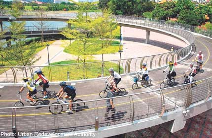
- Not only will more cycling routes be built, the Government will also take measures to promote a pro-cycling environment. For a start, the National Cycling Plan will grow the network of cycling paths from 230km to more than 700km by 2030. All 26 HDB towns will have their own intra-town network, with paths for recreational and short commuting purposes, and eventually these will all be connected to each other.
- With the prospect of a vast slice of coastal land being freed up once the ports move from Pasir Panjang and Tanjong Pagar to Tuas by 2027, some ideas have already emerged from government planners for the 1,000ha area that will be known as the Greater Southern Waterfront. These range from erecting a barrage around Pulau Brani to form another reservoir and a network of streetside canals, to creating a single continuous waterfront promenade that snakes around the coast.
- A new commercial belt in Woodlands with Woodlands Regional Centre housing the first business park cluster in Singapore's northern area.
Some land will also be carved out for small and medium- sized enterprises, which will benefit from being close to Malaysia via a future cross-border rail link. Woodlands Regional Centre is part of a larger commercial belt called the North Coast Innovation Corridor, first announced in the Government's Land Use Plan released in January. The draft plan has specific development targets for Woodlands North Coast and Woodlands Central, which together form Woodlands Regional Centre.
- Established estates will not be left out in the cold when new residential blocks spring up under the new masterplan as there are rejuvenation plans for mature estates that will mean newer facilities and more community spaces. The aim is to ensure that those living there will not be left behind while also encouraging more interaction among residents and improving the environment.
[[nid:61124]]
- Serangoon Gardens is to be designated an identity node and the future of the Serangoon Garden circus near Chomp Chomp is safe. Identity nodes are places with distinctive character, such as Pulau Ubin, Thomson Village and Balestier, so efforts are made to retain some of their unique characteristics, like roundabouts or conserved shophouses. Now street-block plans will be drawn up to guide new developments so that they retain the area's identity and charm.
- Holland Village, designated an identity node and to be extended by 6ha, will enjoy a fresh injection of life with a mixed development, new community park and more pedestrian walkways. The proposals are seen as a way to extend an area already widely regarded as a successful enclave and not as an attempt to change its character. The streets will also be made pedestrian-friendly, with a proposed access road that will divert traffic from the heart of the area. This road will run through Holland Village, connecting Holland Avenue and Holland Drive and lead to a basement carpark to be built by the mixed-use project's developer.
-With foodies beating a path to Jalan Kayu in great numbers, this area too has been designated an "identity node". The URA intends to improve access and visitor experience to the historical street. It will alleviate parking woes by improving the Lorong Semat link between the road and nearby Thanggam LRT station, giving diners a more convenient mode of transport. To make it safer for pedestrians a row of trees will be planted beside the walkway to act as both a buffer and a beauty touch.
![]()
Get a copy of tabla! for more stories.
[[nid:61124]]