Flash floods: What, why and which roads to avoid

PHOTO: The Straits Times
As global temperatures rise, we will have to live with an increase in the frequency of nature-influenced traffic disruptions, in the form of flash floods. But just how does a flash flood occur?
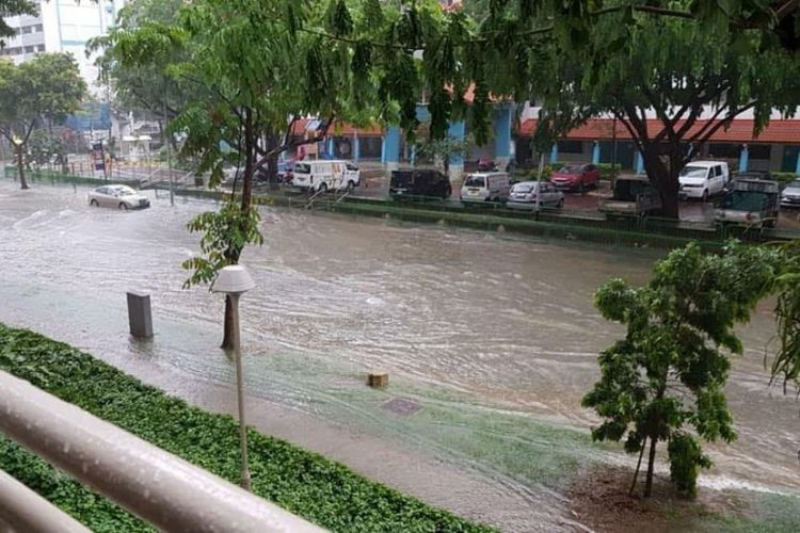
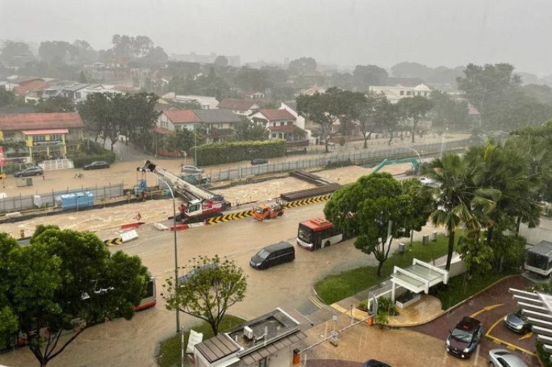
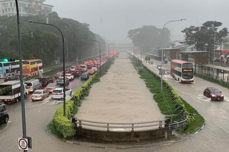
As August draws to a close, we have had two consecutive days in which flash floods made the headlines. Disrupting traffic, this act of god also damaged cars and inconvenienced many others.
The rain is expected to continue, due to the Indian Ocean Dipole, until at least October. Bearing that in mind, here’s a quick guide to what triggers flash floods, and some tips on what to do if you have the misfortune to be caught up in one.
Wikipedia describes a flash flood as a “rapid flooding of low-lying areas”, triggered by a severe thunderstorm. As a rule of thumb, if rainfall exceeds 30mm of rain per hour, you can expect flash floods to form in vulnerable areas.
But excessive rainfall is only part of the equation. Sustained flash floods happen because more rain falls than the drains are capable of shifting.
As the climate continues to worsen, and as the ice caps continue to melt, there will be an increased incidence of extreme weather events.
As a significant portion of our landmass used to be low-lying mangroves and floodplains, that we have since reclaimed and built over, the natural barrier against flooding has been removed.
Rain will still behave in the same way, falling and draining into these areas that no longer serve its intended purpose. In the absence of artificial drainage, we can expect to experience some “surface water” flooding.
Even in ‘natural’, unreclaimed areas, floods can still occur. When rainfall exceeds a drain’s designed capacity, or if said capacity is affected by debris, it can cause excessive water to overflow and flood the surrounding areas.
ALSO READ: Which SUVs would fare well against the flash floods we've been experiencing lately?
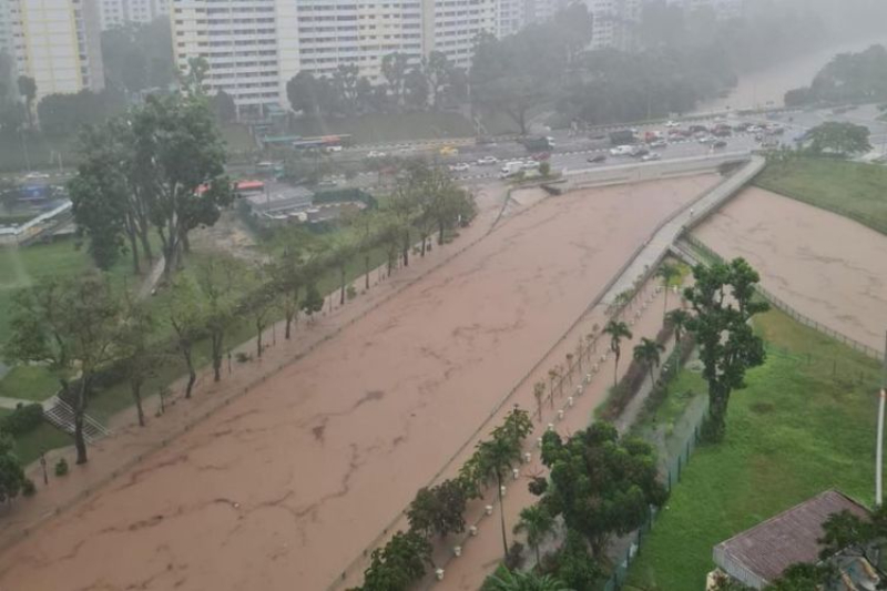
The flooded roads you see online tend to happen as a result of the overflowing of a nearby canal.
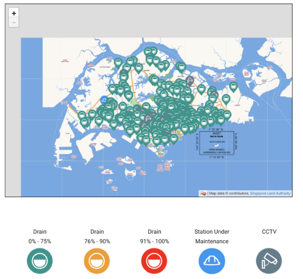
PUB has fitted water level sensors to monitor our drainage systems, and they communicate the status of each water body with a three-coloured legend.
Green represents a zero per cent - 75 per cent low flood risk, Yellow a 76 per cent - 90 per cent, moderate flood risk, and Red is 90 per cent - 100 per cent high flood risk.
Floods cause traffic tailbacks, whilst also causing severe damage to any home, commercial property or vehicle, that has had the misfortune of being caught up in one.
There are areas that have been labelled as flooding hotspots.
But there are also roads that have flooded before and may flood again. Here’s a list of other roads that we have compiled from our research.
| Admiralty Road West near Sembawang Shipyard |
| Alexandra Road / Jervois Road / Bishopsgate Road |
| Beach Road |
| Bedok South Rd / Bedok South Ave 1 |
| Bukit Timah Road / Dunearn Road |
| Chin Cheng Ave |
| Commonwealth Ave / Commonwealth Drive / Queensway |
| CTE near Slip Road to Moulmein Road |
| Delta Road / River Valley Road / Delta Avenue |
| Farrer Park Area (including Thomson Road / Derbyshire Road / Farrer Park Field) |
| Hong Kah area |
| Hougang Ave 8 / Punggol Way slip road |
| Indus Road |
| Jalan Benaan Kapal |
| Jalan Besar Area |
| Jalan Gembira |
| Jalan Kemboja / Mulberry Ave / Jalan Wangi |
| Jalan Mashor |
| Jalan Mat Jambol |
| Jalan Seaview / Tanjong Katong Road South |
| Jalan Taman |
| King George’s Avenue (People’s Association HQ) |
| Kramat Lane / Cavenagh Road |
| Langsat Road Area |
| Lorong Buangkok |
| Lorong H Telok Kurau near Siglap Canal |
| Lower Delta Road / Alexandra Road |
| Margaret Drive / Tanglin Road |
| Meyer Road / Fort Road / Arthur Road / Margate Road / Ramsgate Road |
| Mimosa Walk |
| Mindef’s Changi Camp off Farnborough Road |
| Neo Pee Teck Lane / Pasir Panjang Road |
| New Upper Changi Road (Chye Heng Garden) |
| Rose Lane |
| Second Chin Bee Road |
| Sennett Estate (Puay Hee Avenue / Siang Kuang Ave / Wan Tho Ave, |
| Service road off Tampines Road (near Jalan Teliti) |
| South Bridge Rd / North Canal Rd / Upp Hokkien St / Upp Pickering St |
| Stevens Road / Balmoral Road |
| Tampines Avenue 10 / Pasir Ris Drive 12 |
| Upp East Coast Road (junction with Parbury Avenue) |
| Waterloo St / Albert St / Bencoolen St / Prinsep St |
| Zion Rd (Boys' Brigade HQ) |
*Information found was taken from PUB’s website, Straits Times and CNA.
That being said, flash floods may still appear in areas that are not low-lying areas, or a designated ‘flood hotspot’.
As with anything in life, a bit of common sense goes a long way. Unless you are absolutely sure water levels are low enough, do not drive through deep pools of floodwater.
Stay tuned to the radio stations when there are bad storms, and drive safe and keep a lookout for others on the road!
ALSO READ: 'Will I need to swim downtown?' Netizens on flash floods in Bukit Timah
This article was first published in Motorist.